About "Safe Crossing"
At a glance
Safe Crossing is a project based on a crowdsourced effort to assess if the setup of pedestrian crossings in Luxembourg-City complies with the Code de la route (Highway Code). Specifically, users were asked to analyse whether there were parking spots within five metres of a pedestrian crossing, which is prohibited according to the Code de la route.
Results:
- A total of 1787 pedestrian crossings were analysed.
- The setup of 475 (27%) crossings is likely in violation of the Code de la Route
- For 162 (9%) crossings, no assessment was possible
The remaining 1150 (64%) pedestrian crossings have been assessed as being in compliance with the Code de la Route.
This means that roughly a third of all pedestrian crossings in the City of Luxembourg may not be set up according to the rules of the law, despite the fact that such flaws had already been brought to attention of city by an audit on pedestrian security in 2015.
In the press
The Safe Crossing project had a big impact and was well covered by Luxembourg's national press. Articles about or mentioning Safe Crossing (chronological order):
2021
- WOXX (DE) - 21.10.2021 - Illegale Zebrastreifen in Luxemburg-Stadt
- Luxemburger Wort (DE) - 08.11.2021 - 475 gefährliche Zebrastreifen in der Hauptstadt
- Luxemburger Wort (FR) - 08.11.2021 - 475 passages piétons dangereux dans la capitale
- Contacto (PT) - 08.11.2021 - Uma em cada três passagens de peões na Cidade do Luxemburgo não respeita a lei
- Luxembourg Times (EN) - 08.11.2021 - One in three pedestrian crossings in city in breach of law
- Paperjam (FR) - 08.11.2021 - 475 passages pour piétons non conformes à Luxembourg
- Delano (EN) - 08.11.2021 - One third of the capital's pedestrian crossings potentially dangerous
- 100komma7 Presse Revue (LB) - 08.11.2021 - Audio (roughly at 2m09s)
- RTL Today (EN) - 09.11.2021 - Crowd-sourced initiative assesses safety of Luxembourg's pedestrian crossings
- Les Frontaliers (FR) - 09.11.2021 - Un collectif dénonce un manque général de sécurité pour les piétons dans la capitale
- actuLuxembourg (FR) - 10.11.2021 - Luxembourg : les passages piétons de la capitale sont-ils dangereux ?
- 100komma7 Panorama (LB) - 10.11.2021 - Episode link (roughly at 6m20s in audio clip)
- Tageblatt (DE) - 15.11.2021 - Aktivisten: „Viele Zebrastreifen in Luxemburg-Stadt sind potenziell nicht regelkonform“
- L'essentiel (FR) - 15.11.2021 - Certains passages pour piétons posent problème
- Luxemburger Wort (DE) - 16.11.2021 - Eine Diskrepanz bei den Zahlen
- RTL Today (EN) - 16.11.2021 - City officials doubt accuracy of crowd-sourced platform that intends to mark unsafe zebra crossings
- RTL (LB) - 16.11.2021 - Stad Lëtzebuerg reagéiert op Zebrasträifen-Analys
- RTL 5 Minutes (FR) - 16.11.2021 - La Ville de Luxembourg défend la conformité de ses passages protégés
- Luxemburger Wort (DE) - 22.11.2021 - Fußgängerkollektiv ZUG gibt sich nicht geschlagen - „Kein Kompromiss bei Fußgängersicherheit“
- Delano (EN) - 22.11.2021 - Capital working on improving their zebra crossings
- Paperjam (FR) - 23.11.2021 - La capitale travaille à l'amélioration de ses passages piétons
- WOXX - Am Bistro mat der WOXX Podcast (DE) - 10.12.2021 - Podcast: Am Bistro mat der woxx #171 - Den Zentrum fir Urban Gerechtegkeet an d'Zebrasträifen
- ProVelo-Info 124 4/2021 (EN) - 12.2021 - Safe Crossing Project Luxembourg (page 20)
2022
- d'Lëtzebuerger Land (DE) - 21.01.2022 - Die Verletzlichen
- Tageblatt (DE) - 04.02.2022 - Streit um Zebrastreifen: Aktivisten legen härtere Gangart ein – und fordern Informationszugang
- WOXX (DE) - 11.02.2022 - Aktive Mobilität: Sichere Wege nur für Autos
- RTL (LB) - 21.02.2022 - Fir méi Gerechtegkeet an de Stied a méi Transparenz vun den Administratiounen
- RTL Today (EN) - 21.02.2022 - Centre for Urban Justice advocates for better road safety in the capital
- RTL (LB) - 25.02.2022 - Zesumme mam Zentrum an den zoustännege Servicer un een Dësch setzen
- RTL Today (EN) - 27.02.2022 - Luxembourg City alderman reacts to criticism from Centre for Urban Justice
- WOXX (DE) - 17.03.2022 - Informationszugang: Transparenz für Zebrastreifen
- Tageblatt (DE) - 17.03.2022 - Zebrastreifen-Streit: Stadt Luxemburg muss Dokumente herausrücken
- RTL (LB) - 17.03.2022 - Stad Lëtzebuerg muss Dokumenter iwwer Zebrasträife publizéieren
- L'essentiel (FR) - 17.03.2022 - Des passages piétons illégaux?
- Luxembourg Times (EN) - 24.03.2022 - No need to hide dangers for pedestrians, city told
- Luxemburger Wort (DE) - 26.03.2022 - "Uns hat nicht gefallen, wie es abgelaufen ist"
- ARA City Radio (EN) - 08.04.2022 - Local Matters: Road Safety
- WOXX (DE) - 05.05.2022 - Illegale Zebrastreifen: Keine Einsicht
- WOXX (DE) - 14.07.2022 - Crowdfunding für Zebrastreifen
- Luxemburger Wort (DE) - 20.07.2022 - Stadt Luxemburg muss sich vor Gericht verantworten
- Luxemburger Wort (FR) - 20.07.2022 - La capitale doit répondre de ses actes devant la justice
- Luxembourg Times (EN) - 20.07.2022 - Luxembourg City faces lawsuit over risky crossings
- L'essentiel (FR) - 20.07.2022 - Les passages piétons en justice
- WOXX (DE) - 21.07.2022 - Eis Stad gewinnt gegen Stad
- Luxemburger Wort (DE) - 22.07.2022 - Stadt Luxemburg wird erneut zu Herausgabe von Dokumenten aufgefordert
- RTL (LB) - 22.07.2022 - D'Stad Lëtzebuerg muss Dokumenter iwwer Auto-Ëmfro fräiginn
- RTL Journal (LB) - 22.07.2022 - Audio (from minute 7 onwards)
- RTL Today (EN) - 22.07.2022 - Luxembourg City council must make mobility survey results public, says CAD
- RTL 5 Minutes (FR) - 22.07.2022 - Les documents du sondage sur la mobilité devront être rendus publics
- Tageblatt (DE) - 24.07.2022 - Streit wegen Zebrastreifen: Das Kollektiv ZUG geht vor das Verwaltungsgericht
- 100komma7 (LB) - 23.08.2022 - Wéinst net-konformen Zebrasträifen: ASBL "ZUG" wëllt géint VDL op d'Geriicht
- 100komma7 (LB) - 23.08.2022 - Panorama
2023
- Luxembourg Times (EN) - 03.01.2023 - Ignoring public is transparency rules breach, panel says
Official reactions & politics
The City of Luxembourg has not provided official statements to the press after initial requests by the Luxemburger Wort and Tageblatt, apart from a late reference to the city council meeting of 15 November 2021 (see below).
The Ministry of Mobility and Public Works, commonly abbreviated as MMTP, has provided an official statement to the Luxemburger Wort in which they state that it's not the parking spots next to the pedestrian crossings that are illegal, but parking on them is forbidden - basically confirming the point made by the Safe Crossing project.
One official question and one motion were submitted to the city council as a direct consequence of the Safe Crossing project. The question was submitted by François Benoy of "déi gréng" (greens). The motion was submitted by "déi Lénk" (left). Both were discussed at the city council meeting of 15 November 2021.
The city council meeting of 15 November 2021 at which city officials had to react to the Safe Crossing project as a consequence of the questions by "déi gréng" and "déi Lénk" is online. Translated minutes will be available in a couple of months on the City of Luxembourg's website.
Statement of ZUG following the city council meeting of 15 November 2021
ZUG welcomes the debate and is very pleased that the topic of pedestrian safety got a new jolt of energy.
We have sent a statement with our reaction following Luxembourg-City's city council meeting of 15 November 2021 to Mr Goldschmidt at his professional e-mail address on 18 November 2021.
ZUG has not received any answer from the City of Luxembourg as of 5 December 2021.
"Freedom of Information" request
As part of the Safe Crossing Advent Calendar, a legal freedom of information request based on the Law of 14 September 2018 has been sent to the City of Luxembourg. In this request, we have asked to obtain documents relating to:
- the City's own analysis of the crosswalks that are non-compliant with the CdlR according to the Safe Crossing project
- the City's own analysis of all crosswalks on its territory
- geographical databases of the Topography Department relating to pavements, road marking and parking spots
- the agreement between the City and the MMTP about the interpretation of articles 164(2)(e) and 166(h) of the Code de la Route and their application within the territory of the City of Luxembourg
- the City's Traffic Department's own interpretation of the same articles
- the City's Legal Department's own interpretation of the same articles
- the presentation of the 37* crosswalks that the City considers to be non-compliant
- slides prepared by the City for the "Urban transport" advisory committee meeting of 2 December 2021
The PDF version of the request can be downloaded here.
*: A non-public meeting of the "Urban transport" advisory committee was held on 2 December 2021 as a direct consequence of the motion introduced by "déi lénk" (the left) at the city council meeting of 15 November 2021. At the meeting, the officials were now speaking about 37 non-compliant crossings, opposed to 32 at the city council meeting.
"Non-answer" to the FOI request by the city of Luxembourg
After having prolonged the deadline by one month on the eve of the initial deadline (6 January 2022) for reasons of the apparent complexity of ZUG's request and due to the apparent need to redact personal information from documents, the city has finally submitted an answer on 28 January 2022. In this answer, the city refuses to answer 90% of the questions, and the reasons for which it has delayed the deadline do not apply to the only provided document.
As a consequence, ZUG has lodged an appeal with the "Commission d'accès aux documents". The commission has 2 months to issue an opinion on the matter.
ZUG has also published a press release for the occassion, which can be downloaded here.
What is the project about?
Safe Crossing is a project that aims to highlight and assemble a list of pedestrian crossings within Luxembourg-City that appear to be in violation of Articles 164(2.)(e) & 166(h) of the Code de la Route:
Art 164(2.) (excerpt)
L'arrêt des véhicules ou animaux est interdit:
(e) sur les passages pour piétons, les passages pour piétons et cyclistes, les gués pour piétons et les gués pour cyclistes ainsi qu'à moins de 5 mètres de part et d'autre de ces passages ou gués, sauf signalisation dérogatoire temporaire ou sauf autorisation de l'autorité délivrée à titre temporaire
Art 166(h) (excerpt)
Le stationnement des véhicules ou animaux est interdit:
(h) sur les passages pour piétons, les passages pour piétons et cyclistes, les gués pour piétons et les gués pour cyclistes ainsi qu'à moins de 5 mètres de part et d’autre de ces passages ou gués
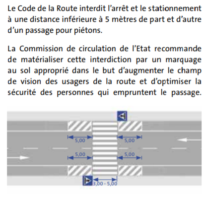
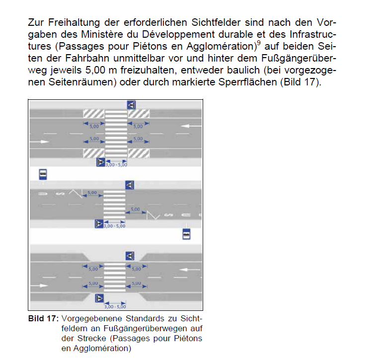
Furthermore, the MDDI (now MMTP) recommends that this prohibition is materialised by appropriate road markings in order to increase the field of vision of road users and to optimise the safety of pedestrians. (Source: Guide de la Commission de Circulation de l'Etat avril 2014 - "Guide Circulation")
Two snippets taken from the Guide Circulation:
You can read more about how the data was collected below, as well as to why this project was launched.
The result of the project, which is the list of crossings that have been identified to be likely in violation of the above paragraphs of the Code de la Route, can be visualised on a map, or downloaded as GeoJSON or CSV.
You can consult the full text of the Code de la Route on legilux.
How was the data collected?
Safe Crossing is a crowd-sourced project. As such, the data has been generated in 2021 (from June to August) through a collective effort involving around 20 active volunteers. Volunteers have been approached on social media to ask whether they would be interested in participating.
Interested users were invited to install a custom-made application on their phone. Upon launch, the application presented users with a pedestrian crossing in Luxembourg-City on a map using satellite imagery. The volunteer was then asked to assess whether there were parking spots within five metres of the pedestrian crossing in question. The volunteers were able to measure the distance using a dedicated feature of the app that allowed them to draw a circle with a five-meter radius and move it around the screen freely. This way, the distances around the pedestrian crossing could be measured with adequate accuracy.
Volunteers could then click one of three buttons: one button to state that there were no parkings within five metres of the pedestrian crossing (which would be in compliance with the law), another button to say that there were parking spots within five metres of the pedestrian crossing (which would be in violation of the law), and a last button to indicate that they were not sure of that it was impossible to tell (for example because trees impeded visibility of the pedestrian crossing on all available images, or because there was no crossing there anymore).
After making a choice, the volunteer was presented with a new pedestrian crossing, and so forth.
The only exceptions to this procedure are listed, if applicable, under the relevant item in the changelog at the end of the page.
Some screenshots:

At what point did data collection stop?
Data collection stopped when all crossings in the database had at least 5 votes each. A threshold of 5 votes as a minimum per crossing was subjectively chosen to ensure that a somewhat robust conclusion can be drawn about the pedestrian crossing's setup's compliance with the Code de la Route.
How was the collected data processed?
Once data collection had finished, it was minimally processed. The only processing that took place was concerning crossings for which there was a tie after voting (that is, there was a tie between the possible outcomes that the crossing was in compliance with the law or not, or that it was impossible to say for volunteers). For these crossings, a manual intervention took place and a decision was made by a single volunteer to overturn the tie and assign a definitive status of being in compliant with the, or not being compliant with the law, or deciding that it was not possible to judge based on the satellite imagery.
Interpretation of the results
While no quality assurances can be made about the data as it has been crowd-sourced (and as it is subject to human error and factors like the quality of the data on OpenStreetMap or the aerial imagery of Geoportail), the results are highly indicative of a general lack of safety for vulnerable road users in Luxembourg-City and in specific pedestrians. Roughly a quarter of all pedestrian crossings in the database were marked as having parking spots in a too close vicinity. This means that at all those crossings, there exists unnecessary danger for pedestrians as visibility is impeded and moving safely might be difficult due to the vicinity of parking spots.
What's the motivation for this project?
Luxembourg City is a beautiful, vibrant city. However, it is also a city with a lot of individual, motorised traffic and therefore suffers from a lot of the disadvantages that come with the latter: congestion, noise, pollution - and also a high risk for pedestrians and cyclists.
Every human being that is hurt on our streets is one too many - and city leaders should do everything in their power to protect people as they walk or cycle. However, it turns out that when it comes to one of the most basic infrastructures for soft mobility, pedestrian crossings, there has been a lot of "creativity" to squeeze in more parking spots at the expense of pedestrian safety.
Most often, this creativity manifests itself as starting the kerbside parking spots already well before the 5 metre minimum distance from the pedestrian crossing, but only letting the designated lay-by reach the full width exactly at the 5 metre mark. This is technically allowed by the Code de la Route, but on many pedestrian crossings this flexibility is stretched to the absolute maximum.
On a great number of pedestrian crossings, there is simply no minimum distance left at all. On other occasions, and most often in 30 km/h zones, there are no markings on the ground - neither for pedestrians, nor for cars. But in practice this means that drivers will take up every square inch for parking, disregarding that they impede visibility for pedestrians and cyclists but also other drivers.
To illustrate the importance of visibility at pedestrian crossings, the following animation taken from Twitter is very powerful:
Stabiņi Rīgas ielās vajadzīgi, lai bērnu ceļš uz skolu būtu drošs. pic.twitter.com/jxClayY3Bc
— Oto Ozols (@otucis) October 18, 2021
Jumping back to Luxembourg-City, take a look at the following example: the street on the top has adequate field of vision of the pedestrian crossing, while on the bottom one, parking spaces are put right next to it. Approaching drivers are unable to see pedestrians trying to engage on the street. As a consequence, they are exposed to unnecessary danger.

Therefore, this project aimed to highlight the extent of the problem, but also to show where the problematic crossings are. The ambition was one of positive citizen-powered action to help make the City of Luxembourg a safer place. City leaders are welcome and in fact encouraged to draw on the collected data to improve dangerous pedestrian crossings and align their setup with the Code de la Route.
What are the sources for the initial list of pedestrian crossings and the satellite imagery?
The initial list of pedestrian crossings in Luxembourg-City has been drawn from OpenStreetMap, © OpenStreetMap contributors. Satellite imagery has been provided by Geoportail (2020 Ortho-Photos).
Changelog
- 2021/10/20: Initial release. All numbers and statistics on this page are based on this initial release.
- 2021/11/09: Manually added 1 likely non-compliant crossing. A citizen approached us after the release of the dataset and asked for a missing non-compliant crossing to be added to the list. The crossing was manually checked by one volunteer using satellite imagery and Google Street View and was included in the data (OSM node id 1740533042).
Disclaimer
This is a crowd-sourced effort. The information this homepage and in the dataset is provided for informational purposes only, and no assurances can be made as to the level of accuracy of the presented data. There is no representation or warranty of any kind, not expressed and not implied, regarding the accuracy, adequacy, validity, reliability, availability or completeness of any information on the this website, including the GeoJSON dataset. Use of this website and / or reliance on any data or information on this website, including the GeoJSON dataset, is solely at your own risk.
Licensing & contact
The GeoJSON dataset is licensed as Creative Commons "CC BY-SA", except crosswalk points themselves, which are © OpenStreetMap Contributors. You can contact us at info(at)zug.lu